315
Percentage of Each State Taken Up by Corn Fields
(lemmy.world)
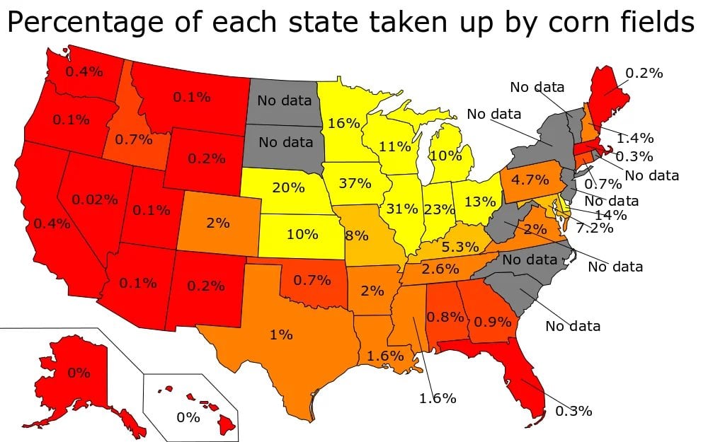
No Data = Stealth Corn
Honestly it fits my theory that one of the Dakotas doesn't really exist.
It's probably where all the birds are controlled from.
One of them certainly shouldn't exist. The fact that that area is split into two states is only to have two more Republican Senators.
State borders are strange. Like why the part of Florida in the central time zone isn't just Alabama doesn't make sense to me.
Imaginary corn. Like John Peters, you know, the farmer, grows.
Get your shit together, Alaska!
Embarrassing
“No data“ it at that point
TIL most US corn is Republican
The second highest on this map, illinois, is a Dem state
To be fair, the corn isn’t growing in the blue part of Illinois
Yes it is. As a resident, I can attest that the corn is growing about damn near everywhere.
Multiple counties in Illinois voted in favor of exploring secession from the state because they don't like how Chicago turns the state blue. It would definitely be a red state without us.
Every state would be a red state without the major cities.
Except Massachusetts apparently.
Only because of Chicago & C(r)ook County. Virtually the rest of Illinois is red.
Yup, and Michigan and Wisconsin are swing states. It’s still the vast majority.
still majority yes, but also minnesota is a solid blue state. It’s maybe like a 75/25 split which isn’t that radical.
In fact, of the yellows, there are 3 Democratic, 2 Swing States, and 5 Republican.
I only found Minnesota and Illinois as consistently Democratic voting states. What’s the third?
Edit: I just saw Delaware.
How does Nebraska factor? Last election they were 2 votes blue three votes red.
Hard to believe there is no data on corn fields in the home state of the Corn Palace.
We are the children...of ethanol.
This makes me wonder what the map creator considers a green amount of corn to be lol. 100%?
And how do we have NO DATA about the crops growing in any state?
Corn has consumed anyone who could answer.
0.4 and 0.7% are different colors, but 10 and 37% are the same
Why are you telling me which states have no data?
I thought this was about corn?
Indiana Beach commercials did not lie to me after all!
I don't agree with the color choice. Green would've been much nicer.
It all should have been shades of yellow.
Monocultures are environmentally devastating btw.
There is a massive swing in each of those colors.
Yeah, 10%, 20%, and 37% should each be ~~buffet~~ different colors.
Damn autocorrect
Really? Only 0.4%?
Because it sure feels like there's way more corn here than that.
If you’re referring to CA, it’s % of the entire state. Think of how much of CA is arid, mountainous, or otherwise unsuitable for corn or other agriculture.
if the numbers seem low dont forget about soy. and maybe wheat or alfalfa
I can't imagine 1/3 of everything you see in an entire state being corn.
Try driving through it. It's horrible.
Can confirm. I live in the Midwest.
Having flown over Iowa in a small plane many times this checks out
I'll be honest, I thought Ohio would be higher...
The other 87% of Ohio is soy beans
Drove through North Dakota once. It was all corn for hours. Absolutely stupid amounts.
ayyyy lifelong nebraska resident here! you can absolutely tell if you ever drive through here, shit’s ALL farmland.
As a foreigner, based on my road trip from Houston to Port Fourchon in Louisiana, I would have thunk those two percentages would've been substantially higher. Especially Louisiana.
For the map enthused!
Rules:
post relevant content: interesting, informative, and/or pretty maps
be nice