505
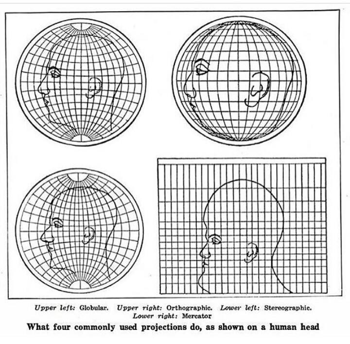
Using a human head to demonstrate map projections
(lemmy.world)

That's Gall-Peters, isn't it?
Potion seller. I'm going into battle and I need your strongest potions.
You can't handle my strongest potions traveler

Surprisingly informative
I don't quite get this. The human head, like the globe, is not flat. Shouldn't that be reflected in the projections? When projecting the earth in Mercator, we see the whole earth, not simply a "profile" of earth. I would expect a projection of a head to include the whole surface of the head, not a simple profile. How is this actually factual?
This isn't representing projections of a human head. This is representing projections of the globe if the globe had a giant human head drawn on it instead of the continents.
But then you have to figure out how to transfer the drawing of the head onto the curved surface, and how you do that is going to determine how the projections look.
No, you can ignore that part. The image isn't showing how to accurately draw a head onto a surface, it's showing how this given head drawing would look in different projections.
Projections from what? You don't need a projection for a drawing, it's already a 2d image.
Edit: I realize that you can use it to compare the different projections to each other, but it doesn't show which one is more accurate overall. In this image it looks like they used the globular projection as the "default' with the most realistic drawing, and created the others based on that, but they could have picked any one of them to be the default.
Yes, again, that's the point.
It assumes the sphere projection is correct, and shows how each of the 2D projections isn't correct. This isn't hard.
This is a better example
That is also a good explanation for how the Shroud of Turin could not possibly be an after-image of a three-dimensional person.

It's still a Mercator projection if you take a world map done in that way and cut it in vertically in half, isn't it?
Same thought, ha.
The virgin Globular map vs the chad Mercator map
Thats honestly fantastic lol
OK, now show us the Goode homolosine equal-area projection human head.
I would, but I have a weak stomach.
So how about the Cahill Butterfly projection, ...
Came here to say this, but you did, so I'll ask for the Dymaxion projection.
I'd say that people who like the Cahill butterfly have bad taste, but then again, I might be projecting.
Ba-da-ching!
Unlike the human head, the earth actually is nearly spherical. There's got to be some differences in how spherical projections work when the object actually is a sphere, I would think. I know that 2D maps are distorted, but are globes actually this distorted as well? Never knew that, if so.
Edit: After reflecting on it for a minute, I see they're demonstrating forms of 2D map distortion. The way depth is represented is variable. With modern concepts of 3D imagery, we must have solved this distortion problem. If you open up Google Earth's globe, it doesn't have such distortion.
All 2D projections are distorted, but some are useful in certain contexts (yes, even Mercator, though not for viewing the entire globe at once). Google Earth is still projecting the image of a globe onto a 2D screen, and there are distortions.
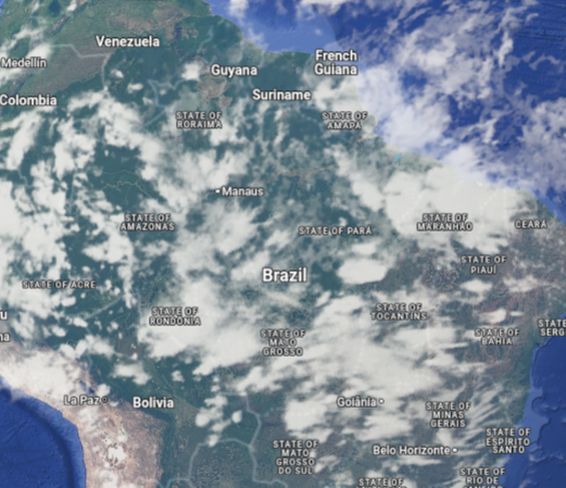
Here's South America straight on in Google Map's globe view:
And South America from the side:
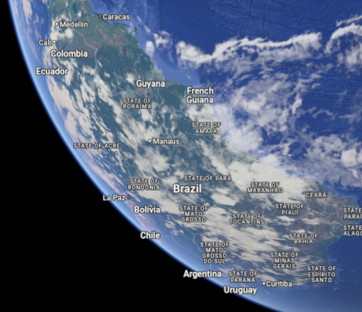
If you measure the distances between, say, Manaus and La Paz with your fingers in these pictures, you'll get different answers. That's just how translating a 3D object to a 2D image works; you can't flatten a globe into a piece of paper without breaking something.
Thank you for illustrating for me. I understand what you're saying.
With modern concepts of 3D imagery, we must have solved this distortion problem.
? You're still taking a three dimensional earth and displaying it on a 2d screen or plane. That will always have distortion on some axes. That's not a technological "problem" to be "solved", that's just mathematical reality.
Yes, that's my point, we have computers that can pretty accurately represent depth, not like the old projections we drew on maps. Stretching it out flat (zooming in on google earth) has less distortion than these projections shown here, don't they?
You've replied to another comment in the thread indicating that you get it, so nice! But just in case other readers are looking here, I'll reply to your comment here as though you were someone else.
we have computers that can pretty accurately represent depth
No, computer (monitors/screens) cannot represent depth. Those are still 2d planes, and cannot represent 3d information without distortion. When computers calculate and display depth, they do so through illusion of depth, perspective, and parallax.
This is not a technological problem, it's physical and mathematical. You cannot consolidate 3d information into 2d information without distorting something.
the old projections we drew on maps.
We still use projections on maps, both paper and electronic. Because we must. They are the only way of taking 3d information and rendering it to 2d information. All projections have distortions, and the map makers takes her pick of what she is distorting (usually size and shape, but it could be direction or continuity a la Waterman Butterfly.) There is nothing special about computers compared to doing a projection by hand, other than it's much faster to do it on a computer.
Stretching it out flat (zooming in on google earth) has less distortion than these projections shown here, don't they?
"Stretching it out flat" is projection*. It may appear to be less distorted to your human eyes because you're zooming in continually as you scroll your mouse, so it looks like it all blends in together. But that doesn't mean it's actually more accurate or less distorted than a map with a reasonably chosen projection for the area. Because you fundamentally cannot take a 3d object and make it 2d while keeping all the information. (Try it yourself! Try to peel an orange while keeping its peel entirely intact and while making the peel come out in a rectangle. No cutting off bits allowed, we want that peel to come right back to wrapping around the orange after.)
Now do my dick
=o
List video game musics that would go nicely along with this one in a "scientific diagrams that look like shitposts" video!
That looks pretty accurate for me
This is perfect lmao
For the map enthused!
Rules:
post relevant content: interesting, informative, and/or pretty maps
be nice