13

Hard, 12.3 mi out and back

3,845 ft elevation gain

Hiked 6/29/25

Full Photo Set

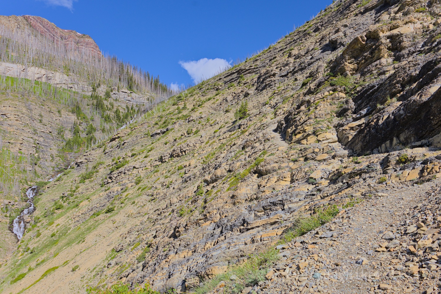
Adding roughly 1600 ft in elevation to the Goat Lake trail as well as crossing a very steep sided scree field with surprisingly good traction, with an epic view from the top. Once on the ridges its wide open, but you'll work to get there. Return the same route or a very long loop using Avion ridge.

Looking towards Newman Peak from the ridge line between it and Avion Ridge. A trail may be seen cutting along the scree to the right to get to the next ridge. It then ascends to the peak and can either loop or return the way you came. I was unaware of the loop and just came back across the scree field.

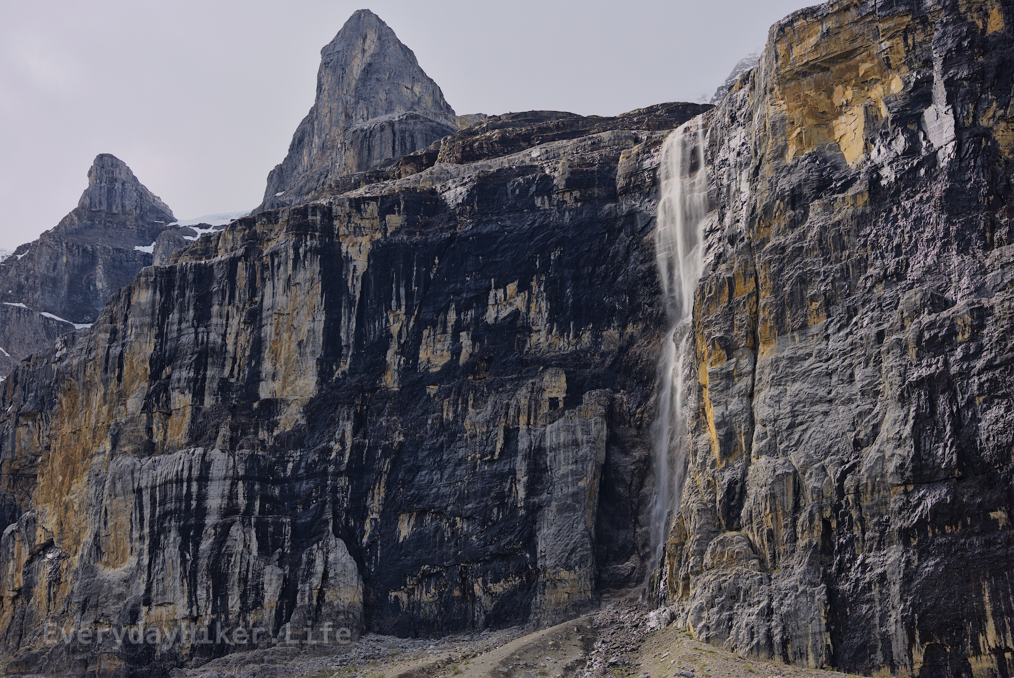
Looking Northeast from the pass below Newman Peak. Spread Eagle mountain in the distance and Yarrow creek flowing from the lake in the valley.

Photo of me on the pass below Newman Peak. The flat area was incredibly wide along this pass.

23

Moderate 8.7 mi out and back, connects to Newman Peak and Avion Ridge trails 2,217 ft elevation gain Hiked 6/29/25

Full photo set, incl. Newman peak and Avion Ridge Loop

2 miles are shared with a mostly level bike path, before it sharply ascends above the previously burned forest up a large valley with a many tiered waterfall in view as a motivator, or excuse for a breather. Above the falls is Goat lake, which is worth extending past a little even if ending here for one more view as it has a great view looking back from just before the next big ascent.

Looking back down the trail you just hiked. The trail may be seen cutting left then righ as it drops. Leftover trees from the 2017 burn leave their mark.

The first good viewpoint of the massive falls complex coming out of Goat Lake. Before the fire this would have likely been the first view of the falls you’d have at all as you emerged from the trees.

Looking out the upper bowl area back towards the way you came. I would consider coming up to this part even if you don't ascend to Newman Peak as its before any real elevation gain and offers better views than Goat lake.

38

Moderate, 9.1 mi out and back 2,264 ft elevation gain Hiked 6/28/25

Flickr image set

Generally mild until a steep ascent up a few switchbacks that get you to the upper twin lakes, this hike will take you along the valley between Rowe mtn and Mt Lineham and provides a variety of great views and wildlife opportunities. A lower Rowe lake is also accessed via a short spur trail. I believe the main Mt Lineham trail shares the milder first 3 miles.

Trail photo showing the up and down from a switchback. While steep, it has great traction throughout. A section of Mt Lineham is seen on the left.

I believe this is considered Rowe Mountain, but I could be wrong. Passed on the left as you go along the trail. Seeing water cascade down the slide area would be a treat.

The creek flow out of Rowe lake left some snowbank overhangs which were great from waiting out the rain.

[-] everydayhiker@lemmy.world 3 points 1 week ago

And just a heads up, I'll be out of cell service until I think Sunday (Isle Royale backpacking) so it'll be a short hiatus on these posts.

21

Moderate 7.3 mi out and back 2,713 ft elevation gain Hiked 6/27/25 Full Photo Set

A couple of flat areas along with a very steep ascent towards the beginning and a fairly steep ascent at the top will take you to a set of 3 small lakes. One is in a lower bowl and is where the campsites are, while the others are above it. Waterfalls below each set of lakes and access to the ridge above, which was too stormy when I was there to go to the top of.

Looking across the larger of Southfork lakes towards Southfork mountain.

A patch of Kings-Crown, Rhodiola integrifolia Raf. growing in the rocky outcrops a short distance from the lake.

A patch of Twinflower, Linnaea borealis L. growing among some dead wood.

35

Nature Walk, up to 1.3 mi 200ft elevation gain Hiked 6/26/25

https://en.wikipedia.org/wiki/Head-Smashed-In_Buffalo_Jump

A museum and two short hikes on the upper and lower areas of this world heritage site where indigenous peoples of the plains used the geography for hunting bison. The museum on site celebrates Blackfoot culture and provides historical context. The design of the museum is well done and enjoyable.

Looking straight on the jump site from below. Over time, the height dropped by 10m due to usage.

A diorama depicting the jump scene.

A winter count robe on display. These were an effective way of marking the passage of time and each symbol delineated what the corresponding years name was.

34

Nature walk, up to 1.3 mi 318 ft elevation gain Hiked 6/25/25

https://en.wikipedia.org/wiki/Frank_Slide

Site of the deadliest landslide in Canadian history, which took place on April 29, 1903. ~44 million cubic meters/110 million tonnes of limestone broke free from Turtle Mountain, burying a section of the town of Frank. The walk tours the rubble field which spilled out over 2 miles. Museum on site.

A diagram displaying the various formations and how they are stacked. Diagram out of frame details that this kind of willy nilly stacking may have contributed to the slide.

The trail along the boulder field has been leveled and cut from the debris, making an easy trek through otherwise rocky terrain. Turtle mountain beyond showing both the slide and the intact sections.

A view of Turtle mountain showing both the slide section as well as the still intact section, which still has the potential to slide as well.

30

Moderate 7.6 mi out and back 1,781 ft elevation gain Hiked 6/24/25

Spending most of the time hiking along a forest service road, this hike offers some view of the Crowsnest mountain area from the valley and a better view of the area up near the cell tower that marks the peak. Ample signs of wildlife, as well as my first sighting of a new favorite, Purple Fringe.

Bigfoot tracks! The previous couple days had been rainy and a bear left a few tracks in the muddier sections. Saw some fresh scat at the end of the trail, but by then it was too dry to make any good tracks.

Sentry mountain, across from the viewpoint at the base of the cell tower.

A beautiful ball of multiple species of butterflies along with a bee. Just don't pay attention to what they're eating.

Full HQ Flickr set

54

Nature Walk, 1.1 mi 127 ft elevation gain 6/20/25

An easy stroll to the source of the mighty Columbia River. Having spent a lot of time working on the other end of this 2,143 mi river, this was a must stop for me. May be good for birding, with fire lilies growing along the sides, it's an enjoyable walk with minimal features. For hydro/geology nerds.

View into the marsh and spring area from the bridge along with a sign depicting the marshland and its confluence of waters. Information section reads:

Source to the Sea

Rising from this hummocky marsh, small streams merge and flow under this bridge to Columbia Lake. From here, the Columbia River flows 2000 km and tumbles over 14 dams to empty into the sea.

As the spring water seeps through the wetland it is cleaned and filtered by plants and soil organisms. So while the lower reaches of the Columbia are quite polluted, here the water is still pure and full of life.

Pedestrian bridge spanning the water in the marshlands.

Water flows from the marshland towards Columbia Lake, this is the furthest point on the loop and has a couple benches out of frame.

49
submitted 1 week ago* (last edited 1 week ago) by everydayhiker@lemmy.world to c/photography@lemmy.world

A multi-use path developed for bikes, this hike may be shortened to I believe as low as 4.4 miles while still seeing the amazing hoodoos they have to offer. I also saw a Dusky Grouse strutting about. Hoodoos are fin-like rays and ridiculous for the ease of access. Near Radium Hot Springs/Kootenay National Park.

The two tower like collections of finned hoodoos at the end of the two outcrops.

The upper tower area of one hoodoo set above Toby Creek.

This ridge line of hoodoos has thinned to little more than a single row. Toby Creek with glacial melt in it flows below.

29
submitted 1 week ago* (last edited 1 week ago) by everydayhiker@lemmy.world to c/photography@lemmy.world

Here are some photos of the Dusky Grouse I saw while hiking on The Johnson, which I also posted today. Pretty sparse forest so I got to watch it strut its way in and out of cover, never taking its eye off of me.

Keeping its eye on me as it gets into a thicket.

A nice angle showing rear tail and the front side as the Dusky Grouse picked its way through the woods.

One last glance over it's shoulder, the Dusky Grouse soon disappeared from sight.

29
submitted 1 week ago* (last edited 1 week ago) by everydayhiker@lemmy.world to c/photography@lemmy.world

Hard 7.5 mi lollipop, could be shortened to a Moderate 6 mi ~2,000 ft elevation gain (~1200 mod) Hiked 6/14/25

Flickr HQ Full set

One of my favorite hikes in Canada, this epic hike takes you along the bowl beneath Stanley Glacier. It begins with a moderate ascent in forest and then flattens as it enters the bowl. From here the trail is officially unmaintained, high use marks the trails. Absolutely recommend doing full hike.

A section of Stanley glacier that is visible from below. I believe this photo was continuing on to the summit trail, which I briefly hiked up.

A cascading stream flows out from the spillway of Stanley Glacier.

A photo showcasing the entirety of the seasonal fall cascading down.

Parts of the Shadow Mountain range in are lit up as the sun breaks free finally.

Various crags along Shadow mountain jut up toward the sky.

Looking into the large bowl from approximately where the trail switches to 'unmaintained', although it is still so well trafficked that it is well defined. Trail becomes a loop from this point.

Looking down the valley from the upper bowl area. The fall may be seen on the left with Mount Whymper outside of the valley center.

[-] everydayhiker@lemmy.world 4 points 2 weeks ago* (last edited 1 week ago)

First time posting on the laptop now that I'm back in the states, anyone know how to add alt text on the main image? I know the body text I just put it under instead, but voyager always has the option for the main. I'll probably use the phone to try to see if I can edit it, otherwise it's: The double falls of Silverton falls as seen from the viewing area, minor rainbow action just below the split.

Edit: If anyone saw this and was also wondering. It is super obvious haha. Between the language and community selection at the bottom.

53
submitted 2 weeks ago* (last edited 2 weeks ago) by everydayhiker@lemmy.world to c/photography@lemmy.world

Easy 1.2 mi Out and Back 394 ft Elevation Gain Hiked 6/13/25

Generally easy with a small washout section during the ascent part of this quick hike, a double waterfall awaits at the end of the trail. One vantage point of the falls with some lower access, I don't believe you can get to the base of it. Great as an 'after hike' or if you just want a small hike.

The water lazily flows downstream from the unseen falls in this last flat area before the quick ascent to the main falls.

The steep quarter mile or so passes over a small washout section, but not bad.

[https://bsky.app/profile/everydayhiker.bsky.social/post/3ltzxw3xkac2y](Bluesky Post) with short video of falls

[-] everydayhiker@lemmy.world 6 points 2 weeks ago

Awesome! Certainly go right ahead, I worry about spamming stuff so personally just leave it to this one post but I think it works great if others say this would be cool on __ and help spread it around.

[-] everydayhiker@lemmy.world 4 points 2 weeks ago

Haha, yeah it was still an absolutely great hike, and this set is actually from the end of my hike when it finally broke up a little bit. If it kept breaking up, some people after me probably got the perfect views with a clouds streaking. Tomorrow’s section to big beehive, which I actually did first, never left the clouds when I was there though, and why I’m all Moody with the clouds haha. Looked cool anyways, but never saw the lake in full.

[-] everydayhiker@lemmy.world 4 points 3 weeks ago* (last edited 3 weeks ago)

Yeah, I believe this is the same spot, or close enough but slightly different perspective. Looks like it could be the same tree as well. Should be in the area between the two parking lots.

Bonus pic from when I passed through there in between when you were there and when I hiked it. Ground is dry but lake is the unsafe frozen. Not quite same view though.

Edit: Also, cool pic while everything was still fully covered.

[-] everydayhiker@lemmy.world 2 points 1 month ago

If you mean Glacier on the US side, yeah my favorite park that I’ve been to. I’ll spend a little time there when I cross over, gotta get in another go on the Pitamakan-Dawson for one thing. I’ve always been there end of season though so it’ll be nice to see this time of year. Waterton will be first time for me.

[-] everydayhiker@lemmy.world 4 points 1 month ago

That sounds like a good adaptation they’re making, even just greater cell phone access is probably making that worse as well. I've definitely had park people scoff at me when bringing up AllTrails in the past, which is usually when I scratch that one off the list of to do’s. AllTrails also shouldn’t be encouraging shortcuts when switchbacks are there for a reason.

I’m sure this is preaching to the choir, but preparation beforehand goes so far too. It never ceases to amaze me how unprepared people are willing to go without even a set idea of where they want to be. I remember one time being at the high point of the High Divide trail in Olympic NP, WA and out of nowhere this panicked kid comes up to me asking for directions. This trail is 19 miles and 5k ft as a dayhike (people usually overnight or two) and he had just pushed on with some girl that was waiting down below a bit. This was at the halfway point so either way would’ve been fine, but he basically bailed before I could adequately explain anything. There’s a short loop of maybe 6 miles that I’m sure was what he meant to do, but how do you go ten miles on a six mile loop without turning around?

[-] everydayhiker@lemmy.world 7 points 1 month ago

The card says ‘moops’.. fixed, thanks

[-] everydayhiker@lemmy.world 5 points 1 month ago

Well , that’s unfortunate. My subscription that I was on the fence about anyways renewed about 10 days ago. Their tracking beats anything else I know of. Garmin Connect is not my favorite UI, but it’ll work.

[-] everydayhiker@lemmy.world 2 points 1 month ago

Thanks! Those are some good photos as well! Yeah, I considered doing green mtn lookout as I was passing through, but ended up not doing it. Think I was more interested in getting a shower in clearwater at that point or something haha, maybe next time. Pretty sure that road to Trophy mtn was still closed at the time but it also sounded like a good one.

[-] everydayhiker@lemmy.world 2 points 1 month ago

I’m hoping I can pull that off in two years, definitely on the list. This is my first trip to Canada and absolutely love it so far.

[-] everydayhiker@lemmy.world 2 points 1 month ago* (last edited 1 month ago)

Thanks! Glad you like them. I’ll be posting one trail a day like this for the foreseeable future. May miss a day or two if I don’t reach cell service but outside of that I should be good. I’ve got two months of canada hikes with one more month up here, plus 1,000 miles worth of trails from last year that I still need to deal with, so I should be able to keep it going for a while.. The plan is to get trail write-ups for everything I do put up on a blog I’m trying to get going, but learning wordpress while spending the majority of your time in the woods is difficult haha. It’s gotten to the point that I need to just start putting some this out there though, and hope that spurs me forward on the rest.

HQ versions of all of these are up on flickr.com/everydayhiker/ as well, with more photos for every trail.

view more: next ›

everydayhiker

joined 1 month ago