90
submitted 1 year ago* (last edited 1 year ago) by 0101010001110100@sopuli.xyz to c/collapse@sopuli.xyz

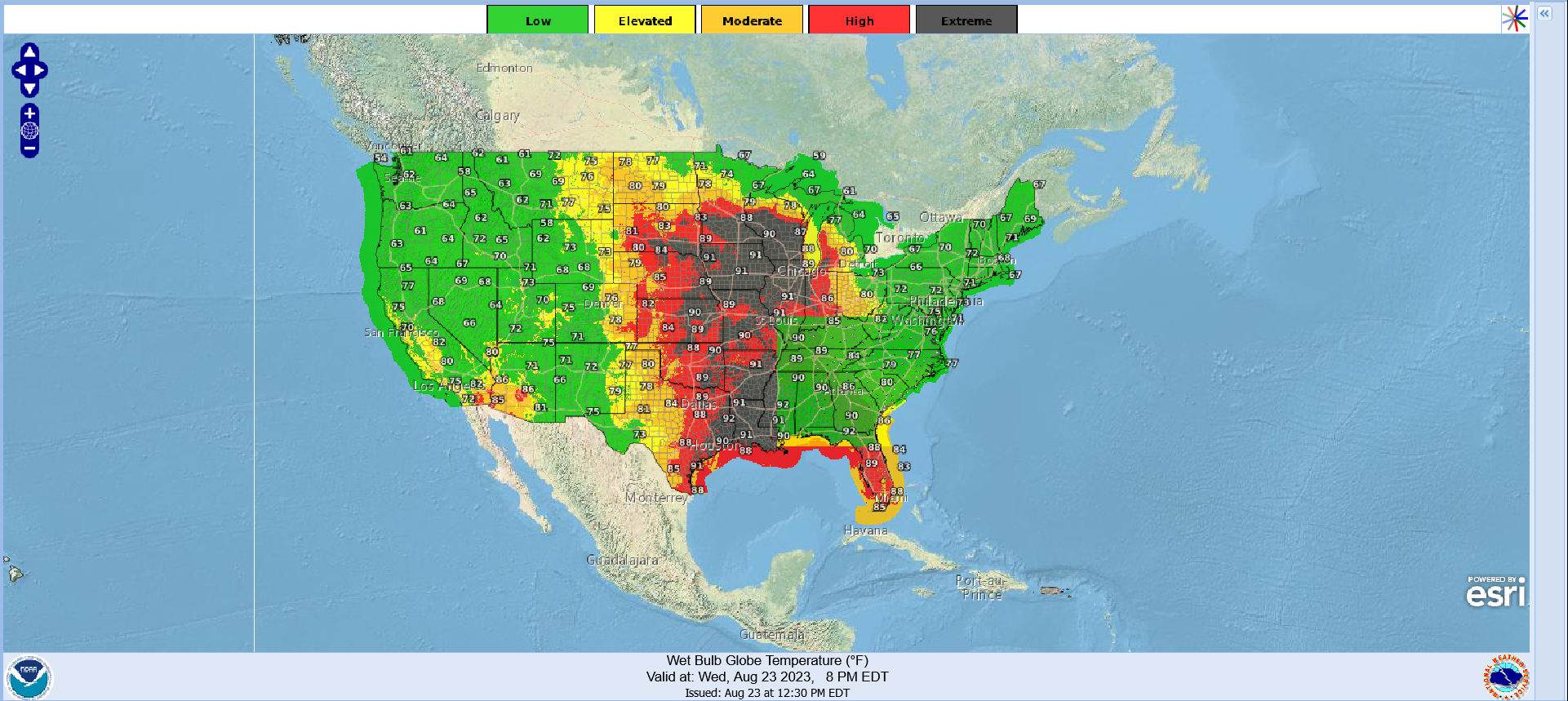
Source: https://digital.mdl.nws.noaa.gov/?zoom=4&lat=37&lon=-96.5&layers=F000BTTTFTT®ion=0&element=8&mxmz=false&barbs=false&subl=TFFFFF&units=english&wunits=nautical&coords=latlon&tunits=localt

If you live in any of these areas, stay safe and healthy and remember to look out for your friends and neighbours who might be vulnerable.

edit: thanks for the correction Deme.
edit2: the temperatures were in Fahrenheit, I guess I switched to Celcius and took the screenshot before the change had loaded. The website seems to reeeeeally struggle with switching units, so I'm going to leave it in (properly marked) Fahrenheit. I don't know, I thought the National Weather Service was going straight to the source, but their website is really shit.

top 11 comments
sorted by: hot top controversial new old
[-] Deme@sopuli.xyz 27 points 1 year ago* (last edited 1 year ago)

*Wet-bulb globe temperature (WBGT) warnings.

Wet-bulb is a part of a measurement instrument (the wet-bulb thermometer).

Wet-bulb temperature (WBT) is the lowest temperature that can be reached through evapourative cooling in the present ambient temperature and humidity. A high WBT results in your body starting to overheat as sweating looses effectiveness.

WBGT is an index for measuring heat stress in direct sunshine. It takes into account the effects of wind speed and solar radiation.

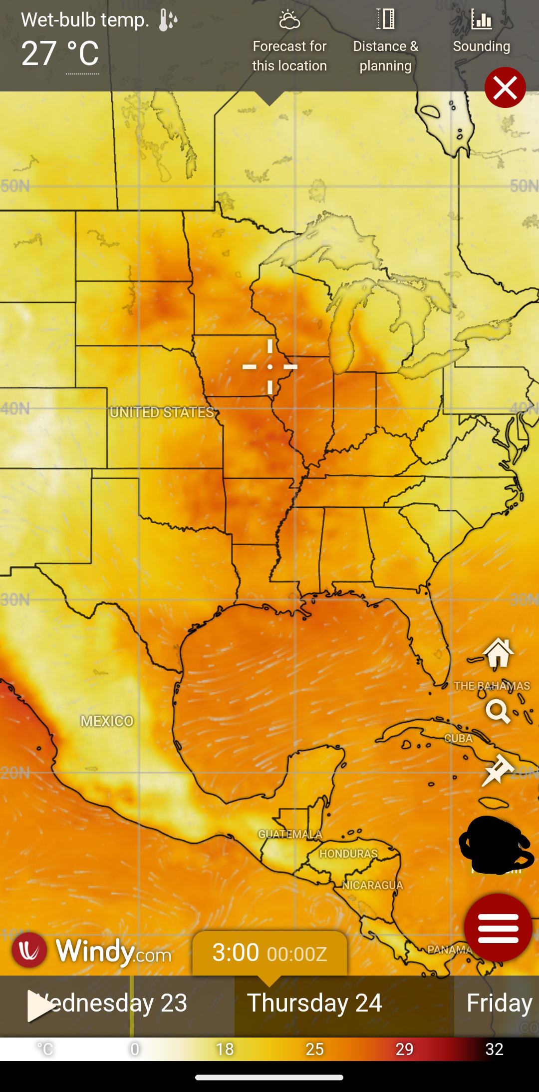
Here's the map for WBT for that timestamp from windy.com using ECMWF data:

The highest WBT I could find there was around 29°C.

[-] droans@lemmy.world 7 points 1 year ago

Fortunately it doesn't seem to be deadly levels. But it's still in the "don't exert yourself too much, carry water, take frequent breaks" level.

[-] siderea@universeodon.com 20 points 1 year ago* (last edited 1 year ago)

@0101010001110100 Thanks for the warning! FYI, wet bulb *globe* temperatures (which this map reports) aren't the same thing as wet bulb temperatures.

When you hear about certain wet bulb temperatures being unsurvivable, the assumption is one has already found shade and that is the wet bulb temperature out of direct sunlight. Or put another way, those fatality limits are if the wet bulb temperature in shade is over a threshold, then it's fatal.

Wet-bulb *globe* temperatures are slightly different: they're the weather forecast in direct sunlight. Moving to shade helps get you into a lower wet-bulb temperature.

So this is Bad, but it's not *quite* as catastrophic as it sounds like.

[-] DarkThoughts@kbin.social 5 points 1 year ago

Is there a site that shows actual wet bulb risk forecasts globally based on accumulated weather data sets? I'm guessing this will become more and more relevant, especially around the equator.

[-] Deme@sopuli.xyz 1 points 1 year ago* (last edited 1 year ago)

Windy.com is a great site and has a layer for forecasted WBT.

Link to the layer

[-] MsPenguinette 4 points 1 year ago

It's not the heat that gets you...

[-] SuzyQ@sh.itjust.works 3 points 1 year ago

I'm in one of the extreme areas. It's been miserable. Last I saw we should be getting a reprise come Friday.

[-] GreenMario@lemm.ee 2 points 1 year ago

All along the Mississippi River too hmm 🤔

[-] HelluvaKick@lemmy.world 2 points 1 year ago

Can't wait to work outside today (live in black region)

[-] Frozengyro@lemmy.world 3 points 1 year ago

Well, at least you'll only have to do it once /s

this post was submitted on 23 Aug 2023
90 points (100.0% liked)

Climate Crisis, Biosphere & Societal Collapse

1156 readers
66 users here now

A place to share news, experiences and discussion about the continuing climate crisis, societal collapse, and biosphere collapse. Please be respectful of each other and remember the human.

Long live the Lützerath Mud Wizard.

Useful Links:

DISCORD - Collapse

Earth - A Global Map of Wind, Weather and Ocean Conditions - Use the menu at bottom left to toggle different views. For example, you can see where wildfires/smoke are by selecting "Chem - COsc" to see carbon monoxide (CO) surface concentration.

Climate Reanalyzer (University of Maine) - A source for daily updated average global air temps, sea surface temps, sea ice, weather and more.

National Weather Service Climate Prediction Center (US) - Information about ENSO and weather predictions.

National Oceanic and Atmospheric Association (NOAA) Global Temperature Rankings Outlook (US) - Tool that is updated each month, concurrent with the release of the monthly global climate report.

Canadian Wildland Fire Information System - Government of Canada

Surging Seas Risk Zone Map - For discovering which areas could be underwater soon.

Check out our sister sub for collapse-related memes and silly stuff, Faster Than Expected!
AKA
c/fte@supoli.xyz

Alternative community on Reddthat

If there are any links you think are important that should be added to the list, please send a message and let me know.

Thanks for coming to c/collapse!

This is a supoli.xyz community.
SUPOLI GENERAL RULES:

  1. Remember the human! (no harassment, threats, etc.)
  2. No racism or other discrimination
  3. No Nazis, QAnon or similar whackos and no endorsement of them
  4. No porn
  5. No ads or spam
  6. No content against Finnish law

Supoli FAQ

founded 2 years ago
MODERATORS