1
35

My partner and I love having live location sharing, it's the main feature of Google Maps that we loathe leaving behind. Is there anything in the OSM ecosystem that replicates it?

So far I found OsmAnd's tracker, which I think works by sending location updates through a Telegram backend or some such?

Is there anything else out there? Anyone else using a feature like this?

2
18
weeklyOSM 760 (weeklyosm.eu)
submitted 2 days ago by strubbl@lemmy.ml to c/openstreetmap@lemmy.ml
3
209
submitted 5 days ago* (last edited 5 days ago) by ray@lemmy.ml to c/openstreetmap@lemmy.ml

Repo: https://github.com/ciupava/maptcha_dev

Demo: https://maptcha.crown-shy.com/

I didn't make this I just wanted to share here before I add it to my weekly urbanism roundup newsletter https://urbanismnow.com/

4
17
submitted 5 days ago* (last edited 5 days ago) by Showroom7561@lemmy.ca to c/openstreetmap@lemmy.ml

When mapping buildings, I'll switch between the ESRI and Bing satellite maps, since they both offer different "freshnes" and clarity, depending on the area.

However, when I use my official municipal or regional websites, they have ESRI maps that appear to be quite a bit newer.

Is the licensing different across different ESRI imagery sources, or could I use the more updated one as a guideline?

EDIT: I think I found my answer from the official OpenStreetMap Wiki:

" Esri is a corporate member of the Foundation."

~~"Esri allowed the usage of Esri World Imagery (and its variants) in OSM mapping, without restrictions and requirements. Even attribution is not legally required."~~

~~This is wonderful news! Having satellite images from only a few months ago, rather than a few years ago, is a game-changer!~~

So this might have been overly optimistic. There may be additional licensing restrictions on variants outside what's available in the OSM editor.

5
4
submitted 5 days ago by lnxtx@feddit.nl to c/openstreetmap@lemmy.ml

Hi,

Following the Gulf of Mexico nonsense.

Why, de facto default map, doesn't show names of lakes, seas, oceans, etc.?

6
16

I keep seeing this in edits, but where can you view this "Lyft-owned street-level imagery"??

Even searching for it comes up with nothing.

7
8

I'm sure this has been asked thousands of times, but how do I view the map extracts offline? (.osm and .pbf) Is there a (native) app I can use? Can't find any clear information.

8
12
weeklyOSM 759 (weeklyosm.eu)
submitted 1 week ago by strubbl@lemmy.ml to c/openstreetmap@lemmy.ml
9
16
submitted 1 week ago* (last edited 1 week ago) by xelar@lemmy.ml to c/openstreetmap@lemmy.ml

WIP

10
13
weeklyOSM 758 (weeklyosm.eu)
submitted 2 weeks ago by strubbl@lemmy.ml to c/openstreetmap@lemmy.ml
11
26

Hi, not sure about the english word. How do I map such a passage for water under a road?

12
17

Neostumbler has has a huge update! Better maps, higher scan interval, customizability!

It is an app to contribute to open geolocation through wifi, cell towers or bluetooth beacons. This is faster, energy efficient, resilient and can be fully anonymous.

The database is beacondb.net and can already be used!

Neostumbler can be installed via

13
17
weeklyOSM 757 (weeklyosm.eu)
submitted 3 weeks ago by strubbl@lemmy.ml to c/openstreetmap@lemmy.ml
14
53
submitted 4 weeks ago* (last edited 3 weeks ago) by Kalcifer@sh.itjust.works to c/openstreetmap@lemmy.ml

References

15
20
weeklyOSM 756 (weeklyosm.eu)
submitted 1 month ago by strubbl@lemmy.ml to c/openstreetmap@lemmy.ml
16
19
weeklyOSM 755 (weeklyosm.eu)
submitted 1 month ago by strubbl@lemmy.ml to c/openstreetmap@lemmy.ml
17
15
submitted 1 month ago by ray@lemmy.ml to c/openstreetmap@lemmy.ml
18
28
submitted 1 month ago by ray@lemmy.ml to c/openstreetmap@lemmy.ml
19
8
submitted 1 month ago* (last edited 1 month ago) by jerome_herbinet@mastodon.zaclys.com to c/openstreetmap@lemmy.ml

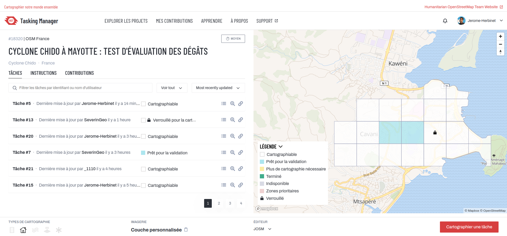
🌀 :openstreetmaps: La cartographie de #Mayotte après le passage du #cyclone #Chido se profile à l'horizon (phase de test) sur #OpenStreetMap via #HOTOSM. Travail obligatoirement via #JOSM. Photos satellites post-cyclone fournies pas le #CNES / #Airbus.
🔗 URL projet : https://tasks.hotosm.org/projects/18320/tasks/
👋 @openstreetmap@en.osm.town @osm_fr @openstreetmap@lemmy.ml
#️⃣ #humanitarian #humanitaire #OSM #climate #climat #solidarité #logicielslibres #opensource #freesoftware #FOSS #FLOSS #cartographie #cartography #hurricane #HOTOSM
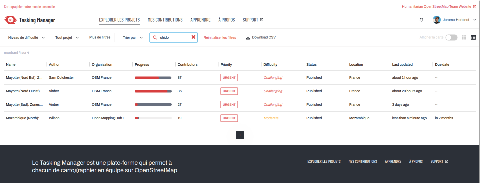
20
20
weeklyOSM 754 (weeklyosm.eu)
submitted 1 month ago by strubbl@lemmy.ml to c/openstreetmap@lemmy.ml
21
61
submitted 1 month ago* (last edited 1 month ago) by redd@discuss.tchncs.de to c/openstreetmap@lemmy.ml

We are thrilled to announce that the OpenStreetMap Foundation has been selected by the Sovereign Tech Agency for a service agreement in the amount of 384,000 EUR over two years to ensure the stability, growth and modernization of OpenStreetMap’s core software.

22
23
weeklyOSM 753 (weeklyosm.eu)
submitted 1 month ago by strubbl@lemmy.ml to c/openstreetmap@lemmy.ml
23
16
submitted 1 month ago* (last edited 1 month ago) by jerome_herbinet@mastodon.zaclys.com to c/openstreetmap@lemmy.ml
24
37
Cartes (cartes.app)
submitted 1 month ago by Valf@lemmy.ml to c/openstreetmap@lemmy.ml

Des cartes en ligne souveraines et modernes, alternatives aux maps des GAFAM.

Tout y sera : recherche lieux, commerces, tourisme, photos, photos de rues.

Itinéraires à pieds, en vélo, en transport en commun et train, voiture partagée, ferry : l'accent sera mis sur les transports écologiques.

25
17
weeklyOSM 752 (weeklyosm.eu)
submitted 1 month ago by strubbl@lemmy.ml to c/openstreetmap@lemmy.ml
view more: next ›

OpenStreetMap community

4424 readers
4 users here now

Everything #OpenStreetMap related is welcome: software releases, showing of your work, questions about how to tag something, as long as it has to do with OpenStreetMap or OpenStreetMap-related software.

OpenStreetMap is a map of the world, created by people like you and free to use under an open license.

Join OpenStreetMap and start mapping: https://www.openstreetmap.org/.

There are many communication channels about OSM, many organized around a certain country or region. Discover them on https://openstreetmap.community/

https://mapcomplete.org/ is an easy-to-use website to view, edit and add points (such as shops, restaurants and others)

https://learnosm.org/en/ has a lot of information for beginners too.

founded 5 years ago
MODERATORS